|
Issued: 0830 Sunday 4th April 2021
Duty forecaster: Claire Darbinyan
Turning colder for a few days with snow for some
High pressure fades as a colder Arctic blast of air moves in from Sunday into Monday when snow is likely to fall, particularly further north. Strengthening winds for some and blustery showers, some wintry, are expected through the week, before we see signs of higher pressure trying to build back in again through next weekend.
For the weather for the next few days click here
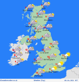
 Wednesday 07/04/21 Wednesday 07/04/21
A chilly day on Wednesday. Sunshine and some showers about, these again are likely to be wintry with snow over higher ground and towards the north and east. A brief ridge of high pressure builds in from the southwest and push eastwards seeing showers largely die out for a time across parts of England and Wales. Further north, the next low pressure system moves in from the Atlantic bringing rain and strengthening winds to northwestern areas during the afternoon. Highs at 5 to 9C.
 Thursday 08/04/21 Thursday 08/04/21
Through Thursday low pressure tracks eastwards to the north of the UK. A westerly flow prevails over northern areas with further outbreaks of sleet and rain for much of Scotland as well as for far northwestern parts of Ireland, England and Wales. Behind the rain, wintry showers follow for northern parts of Scotland. Staying mostly dry elsewhere though early sun tends to fade as cloud builds. High temperatures range from 6 to 11C.
 Friday 09/04/21 Friday 09/04/21
Confidence is low in Friday's forecast. Current model runs are hinting that high pressure builds to the west again with lower pressure staying east which draws a cool northerly flow over the UK and Ireland. Early rain clears southern England with brighter, cooler conditions following from the north. Wintry showers for northern and eastern coasts. Highs range from 4 or 5C in northern Scotland to 11 or 12C in southeast England.
Saturday 10/04/21
Again confidence in the detail is low but Saturday looks to see higher pressure to the west of Ireland. This brings dry and fine conditions to many though northwestern areas could see thicker cloud and patchy, light outbreaks of rain and sleet at times. Highs at 4 to 9C.
Sunday 11/04/21
Models want to see higher pressure staying to the west of Ireland with conditions very similar to Saturday. There is some uncertainty as to where the high pressure is centred but for most it will be another fine and dry day. Cool with highs of 4 to 9C.
Monday 12/04/21
Monday is expected to see high pressure staying west of Ireland. Again, northwestern areas may see thicker cloud and patchy rain or drizzle at times but most see a fine and dry day with highs of 6 to 9C.
|
