|
Issued: 0930 Thursday 18th April 2019
Duty forecaster: Claire Darbinyan
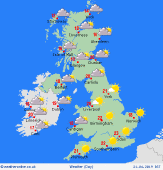
Looking dry and bright for most for the holiday weekend
Temperatures are generally on the increase through this week as our winds shift from the northeast to southeast drawing in warmer air. It should be mostly dry and fair through the holiday weekend though cloud will build into the northwest bringing a few spots of rain for Scotland. Forecast models are now favouring a scenario where high pressure stays dominant to the east through the end of this month bringing dry and bright conditions to eastern areas. Cloudier in the west with some showers developing at times.
 For the weather for the next few days click here For the weather for the next few days click here
Easter Sunday 21/04/19
Sunday sees the arrival of low pressure in the far northwest so it will be an overcast day for the island of Ireland, Scotland, much of Wales and the north of England. Any early morning mist or fog patches should clear quickly as temperatures rise. Showers over Scotland through the morning should ease for most by the afternoon although a few spots of rain may linger in the northeast. Elsewhere it should be a mostly dry day, feeling particularly warm in the sunshine in the southeast. High temperatures at 15 to 21C.
 Holiday Monday 22/04/19 Holiday Monday 22/04/19
It looks as though high pressure will remain dominant through Holiday Monday bringing a dry day with plenty of sunshine to the UK and Ireland. Any early morning mist or fog patches should quickly clear though the sun may remain hazy through the day for western areas. Elsewhere there will be a good deal of sunshine around and it will feel particularly warm inland, away from the coast. Highs at 16 to 21C.
 Tuesday 23/04/19 Tuesday 23/04/19
High pressure should remain in charge on Tuesday for most bringing another mostly fine day across the British Isles. Any early morning most or fog patches should quickly clear once more leaving a bright day. The best of the sun over the north of England, Scotland and the island of Ireland. A small trough may develop over the southwest through the day that could bring some heavy rain through the afternoon and evening. High temperatures at 15 to 20C, warmer in western parts of the UK and Ireland.
Wednesday 24/04/19
Wednesday looks to be a dry and bright day for northeastern areas as high pressure remains over Scandinavia. Cloudier with a chance of showers, which may merge to give longer spells of rain for some, in the in the southwest. Highs at 16 to 20C.
Thursday 25/04/19
A ridge of high pressure over the eastern part of the UK will bring a dry and bright day to eastern parts of England and Scotland. Cloudier in the west and over Ireland with a chance of some heavy bursts of rain developing through the afternoon. Highs at 16 to 21C.
Friday 26/04/19
With high pressure remaining to the east it looks as though it will be another dry and bright day for eastern areas on Friday, cloudier with a chance of a spot of rain in the west. High temperatures at 14 to 20C.
|


