|
Issued: 1000hrs Monday 8th April 2019
Duty forecaster: Garry Nicholson
Slight frosts in mornings
High pressure centred over Scandinavia will maintain an east or southeasterly airflow over the next week or so. A fairly cool pattern, with a risk of regular frost in rural areas, but generally dry. Sunniest in the northwest, locally warm.
 For the weather for the next few days click here For the weather for the next few days click here
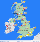
Thursday 11/04/19
Most places will be dry under high pressure and light east to southeasterly winds. Best sunshine in the northwest, cloudier toward the southeast. A fresh breeze on English Channel coasts. A frosty morning, and a cool day, highs 8 to 12C.
 Friday 12/04/19 Friday 12/04/19
Staying generally dry. Variable cloud in central-eastern areas, sunniest skies in the west and northwest. A cool easterly breeze in southern England. Locally warm in northwest Scotland with foehn effect over the hills. Highs 8 to 12C, locally 15C.
 Saturday 13/04/19 Saturday 13/04/19
Little change to the overall pattern, with most places dry. A little drizzly rain or brief showers may come onto east & southeastern coasts. Sunny skies and warmest temperatures again best in the west & northwest. Highs 8 to 13C, locally warmer.
Sunday 14/04/19
Fairly cloudy skies, with patchy rain possible in the east. Sunshine focused toward the west. Cool in the easterly breeze. Highs 8 to 13C.
Monday 15/04/19
A strengthening wind is possible, and again feeling cool. Generally dry, with rather cloudy skies. A risk of some rain coming into the southwest. Highs 8 to 13C.
Tuesday 16/04/19
Not much changing, with possible rain toward the southwest, and a little drizzle in the east, and best sun in the northwest. Highs 8 to 14C.
|
