|
Issued: 0900 Tuesday 9th July 2019
Duty forecaster: Dr. Simon Keeling
Turning drier for the weekend and warmer too
Showery days ahead, with the risk of some thunderstorms in Wednesday and Thursday. Turning drier into the weekend with good spells of sunshine as higher pressure builds. Warmer in the sunshine, and staying dry, warm and sunny into the early stages of next week. Hints of a change by the middle of the week.
 For the weather for the next few days click here For the weather for the next few days click here
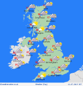
Friday 12/7/19
A north-westerly flow develops on Friday with high pressure to the west of Ireland. There will be sunny spells and it should be a mostly dry start the day. However, scattered showers will develop over Ireland and there is a risk of showers across eastern parts of England as well as central and eastern Scotland. The showers across north east England and Scotland could be heavy. Highs at 23C in southern England, 19C in northern Scotland.
 Saturday 13/7/19 Saturday 13/7/19
Another fine start to the day with a slack pressure flow affecting the whole country. They will be some good spells of sunshine in the morning and these last into the afternoon. Scattered showers are going to be developing again these mainly over high ground. For many areas it will stay dry. High temperatures at 20 to 25C.
 Sunday 14/7/19 Sunday 14/7/19
High pressure is likely to dominate on Sunday. This brings lots of dry weather with good spells of sunshine. Little change during the day. Temperatures rising to between 20 and 24C.
Monday 15/7/19
The area of high pressure should bring another fair day on Monday. They will be plenty of sunshine and it should be dry. Temperatures at 20 to 26C.
Tuesday 16/7/19
High pressure remains on Tuesday. Another dry day with sunny spells for most, although scattered showers forming in Scotland and Ireland. Highs at 21 to 27C.
Wednesday 17/7/19
Lower pressure may be drifting into the southwest of the UK and Ireland on Wednesday. This could encourage some thundery showers tor develop as the day progresses, especially in the west. Highs at a muggy 21 to 27C.
|
