|
Issued: 0900 Tuesday 24th July 2018
Duty forecaster: Dr. Simon Keeling
Mixed overall with some rain for many, staying warm and then drier again next week
The warm weather continues to affect all but the far west of Scotland and western Ireland in the coming week. There are some changes underway which will lead to a higher chance of some areas seeing at least a small amount of rain. Most of the rain will be in western areas where it could be heavy at times, but there is the risk of some localised, thundery rain in eastern areas too. Hints of some not-so-hot days in the southeast before the weather becomes drier again in England, Wales and much of Scotland into the middle of next week.
 For the weather for the next few days click here For the weather for the next few days click here
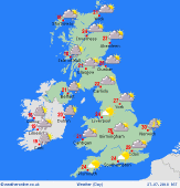
Friday 27/7/18
A change in weather pattern on Friday as low pressure affects the UK and Ireland. Showery rain and the risk of some thunderstorms in central and eastern areas. Fronts moving into the west bringing some cloud and showery outbreaks of rain. Rather a lot of cloud around with a further band of rain passing across Ireland. Highs at 30C in East Anglia, 23 to 28C elsewhere, 19C in Ireland and western Scotland.
 Saturday 28/7/18 Saturday 28/7/18
A ridge of high pressure builds back into the UK and Ireland on Saturday. This brings mostly dry weather with sunny spells, although there may be some residual cloud to the south. A few showers in western Scotland and western Ireland too. Highs at 29C in the southeast, 17C in western Scotland and western Ireland.
 Sunday 29/7/18 Sunday 29/7/18
High pressure holds through northern and eastern areas on Sunday bringing a dry day with good spells of sunshine and feeling very warm again. An area of low pressure may move into southern Ireland in the afternoon bringing cloud and rain here as well as to western and southern Wales and southwest England. Highs at 29C in eastern England, 16C in northwest Scotland.
Monday 30/7/18
Low pressure passing through Ireland and into western Scotland on Monday bringing cloud and rain to the west of the UK and the island of Ireland. Eastern areas of England stay dry, although some rain reaches eastern Scotland and the Midlands. Temperatures at 28C in southeast England, 18C in Ierland.
Tuesday 31/7/18
The chance of some showery spots of rain passing east through Tuesday morning as a weak front clears away. Brighter and drier weather then following as a ridge of high pressure builds again, and so most places becoming fine and dry. Tops near 22 to 28C.
Wednesday 1/8/18
A fair day with sunny spells and feeling warm again. There is the risk of some rain affecting the far west of Ireland and western Scotland, but for most areas it stays dry. Highs at 29C in southeast England, 23C in Ierland and western Scotland.
|
