|
 Saturday Saturday
High pressure to the northwest on Saturday brings a cold north to northwest flow and the risk of a morning ground frost to western areas. There is also a risk of some showers, which may be wintry in nature, in the north and east of Scotland and eastern England where it will be feeling cold. Brighter and drier to the west with sunny spells and just a chance of an isolated shower. High temperatures at just 6 to 7C in northern Scotland, 8 to 11C elsewhere.
 Saturday Night Saturday Night
A mostly dry night with clear skies which will allow temperatures to drop quickly and a frost to form. Some cloud and a slight chance of showers for the Northern Isles and the far northeast of Scotland as well as over East Anglia. Overnight lows falling to -2 to 3C.
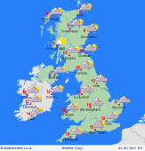
 Sunday Sunday
High pressure brings another chilly start to the day with a risk of a ground frost. A mostly fair day with good sunny spells, although some patchy rain may affect northern Scotland with a few showers along eastern coasts of England too. A few showers may also develop later in the day for Wales and the southwest. High temperatures widely at 8 to 12C, though 13C is possible in the west of Ireland.
 Holiday Monday Holiday Monday
High pressure to the southwest and low pressure to the northeast keeps the UK into a chilly northerly airflow on Monday. The day will start cool with a touch of frost for many. There will be good spells of sunshine and scattered showers for Ireland and Scotland, although a weak front could bring more persistent rain to southern Scotland and northern England. To the south of this it should stay mostly dry with a mixture of broken cloud and some sunny spells. Highs widely at 8 to 11C, though 13 or 14C is possible in the southeast.
|
