|
Issued: 0900hrs Sunday 14th June 2020
Duty forecaster: Claire Darbinyan
Warm and humid with thundery downpours
Only gradual changes in the weather into next week, with a slow-moving warm and humid weather pattern resulting in thundery downpours breaking out most days - locations varied day-to-day.
For the weather for the next few days click here
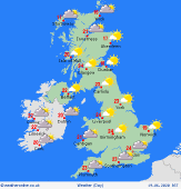
 Wednesday 17/06/20 Wednesday 17/06/20
Hit and miss downpours will develop again, these remaining focussed over western areas with the heaviest bursts expected to the southwest of the UK. Staying warm and humid with little wind. Some places staying dry much of the day. Showers most widespread by afternoon for inland areas. Starting murky with some areas of fog around eastern coasts and hills, these locally persistent for much of the day. High temperatures at 17 to 24C.
 Thursday 18/06/20 Thursday 18/06/20
Pressure is expected to build gradually through Thursday, so showers becoming fewer, these likely focused toward the west of Britain. A trough may be focussed over southern parts of England first thing giving rise to some heavy showers here but these should fade through the morning. Some sunshine, and western areas feeling fresher than previous days. High temperatures at 15 to 23C.
 Friday 19/06/20 Friday 19/06/20
There is still scope for local showers across western Britain and Ireland later in the week, but many places should be dry. Heavy showers may feed into southern England first thing from the near continent but, again, these should ease through the morning. A southwesterly breeze likely to strengthen in the west later. Highs from 16 to 24C.
Saturday 20/06/20
A zone of frontal rain from the Atlantic may move into western Britain and Ireland by the weekend, this reaching western Ireland later on Saturday. Ahead of this, many places largely dry and bright with isolated showers. A warm southerly breeze. Highs at 18 to 25C.
Sunday 21/06/20
Pressure generally staying high though lowering from the west as a frontal system arrives. This system sends bands of rain across Ireland which become more showery and fragmented as the pass eastward over the UK on Sunday. Highs range from 18 to 26C.
Monday 22/06/20
Mixed conditions on Monday as a front brings outbreaks of, sometimes heavy and thundery, rain to eastern parts of the UK. Bright but showery conditions follow from the west for Ireland and the western UK. High temperatures range from 16 to 24C.
|
