|
Issued: 1000hrs Friday 1st September 2017
Duty forecaster: Garry Nicholson
Often warm south & east
A surge of tropical air across the Atlantic will produce very humid conditions next week. There will be a lot of cloud, and some rain at times, which may turn heavy for many places during midweek. In any sunshine, temperatures may reach 25C in the south-east. Later in the week, we expect strong winds and some rain, mainly in the north & west, whilst southern Britain may hold onto dry weather.
For the weather for the next few days click here
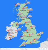 Monday 04/09/17 Monday 04/09/17
A weakening front pushes across Britain overnight producing patchy rain for central regions. A humid atmosphere results in a lot of cloud across the country into the daytime, with a little rain locally. Murky with hill and coastal fog in the west & south-west. Western Scotland may see some persistent rain. A south to south-westerly breeze, strongest in the north. Some sun may break through in the east & south. Highs 17 to 22C.
 Tuesday 05/09/17 Tuesday 05/09/17
The east & south-east should stay largely dry, with some sunshine. Another frontal system spreading from the west brings a threat of rain to Ireland and western Britain, possibly turning heavy for many hours in Wales & north-west England, later spreading toward the Midlands. Showers in north-west Scotland. Winds fairly light as south-westerlies. Feeling humid, highs 21 to 23C south & east, nearer 17 to 20C north & west.
 Wednesday 06/09/17 Wednesday 06/09/17
Rain spreads from the west as low pressure drifts across the country. Some heavy falls are likely for some, but detail is very uncertain. Some places may escape dry with hazy sun, feeling warm and humid. Cooler where rain sets in. Skies brightening from the west, becoming fresher. Possible strong winds, especially around coasts. Highs 17 to 23C.
Thursday 07/09/17
High pressure rebuilds across southern regions, whilst low pressure lies to the north, resulting in a west to south-westerly flow. The strongest winds in northern areas. Rain is likely toward the far north-west. Many places may be dry and bright, and feeling less humid than previous days. Temperatures may reach 22 to 24C south & east, 16 to 20C north & west.
Friday 08/09/17
A continued westerly pattern is likely for northern Britain, bringing rain at times, most persistent in the north-west. The south may stay dry and quite warm. Breezy for all. Top temperatures 16 to 23C, warmest south-east.
Saturday 09/09/17
Confidence low: Wind and rain possible in the north & west, perhaps becoming more extensive. The south may escape dry. Windy, possible gales north. Highs 15 to 23C, warmest south.
|
