|
Issued: 1000hrs Friday 8th September 2017
Duty forecaster: Garry Nicholson
Strong to gale force winds
A series of autumnal lows will move across the British Isles during the week ahead, bringing frequent rain and strong winds. Gales are possible at times, particularly in exposed coastal locations. Heavy showery bursts will be common. Some indication of improvement later in the week as pressure tries to build.
For the weather for the next few days click here
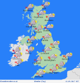
 Monday 11/09/17 Monday 11/09/17
A windy day for all. A deep area of low pressure centred toward the north-east. A cool north-westerly flow brings pulses of heavy showery rain, merging into some longer periods of rain at times in the north & west. Most places will see showers through the day, although there will be bright or sunny spells at times. Blustery winds, locally gusting gale force around exposed coasts and hills. Temperatures just 12 to 17C, warmest south-east.
 Tuesday 12/09/17 Tuesday 12/09/17
Pressure briefly builds overnight, bringing a dry and cool start for many. Another developing low is expected to arrive from the west, bringing wind and rain to Ireland, then rain moving across southern Britain through the day. Heaviest rain likely toward the south-west. East & north-eastern counties may escape dry most of the day. Showery in the north-west. South-westerly winds, strongest near the south coast. Highs 13 to 19C.
 Wednesday 13/09/17 Wednesday 13/09/17
A deep low centred across northern Scotland brings an unsettled day, with strong winds and rain for most places at some point. A cold front clears from southern England. A front encircling northern Britain is likely to bring persistent rain, some heavy falls for western Scotland. Showery bursts almost anywhere. Risk of gales in exposed areas. Temperatures 13 to 18C.
Thursday 14/09/17
Low pressure pulls eastwards into Scandinavia, drawing a cool north-westerly airflow across the British Isles. Strong to locally gale force winds. Sunshine and heavy showers, these locally merging into near-constant rain for several hours. Feeling cool at just 12 to 17C.
Friday 15/09/17
A continued north-westerly pattern, but pressure may build from the south-west later in the week. A few showers, but less widespread than previous days. A better chance for lengthy sunny spells. Breezy, and quite cool. Highs 13 to 18C.
Saturday 16/09/17
A chance that high pressure begins to extend further across the country. Drier weather overall, but a risk of showers continuing for some. A west or north-westerly breeze. Highs 14 to 19C.
|
