|
Issued: 1000hrs Thursday 2nd February 2017
Duty forecaster: Garry Nicholson
Occasional slight frosts
A windy end to this week in the south. Small areas of low pressure will affect the British Isles heading into the weekend, making local detail very uncertain. A south to south-westerly pattern is likely by early next week, bringing rain in from the west. After midweek, a drier but cooler easterly pattern may develop.
For the weather for the next few days click here
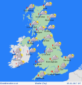 Sunday 05/02/17 Sunday 05/02/17
An area of low pressure is expected to pass to the south of Britain, whilst the remains of previous systems are likely to affect northern regions. Local detail is very uncertain. Areas of showers, perhaps some more persistent rain for some, but there will be a good amount of dry and bright weather also, and some places may escape with a largely dry day. Blustery around southern coasts. Local frost at first in rural areas. Highs 6 to 9C.
 Monday 06/02/17 Monday 06/02/17
A risk of frost in the morning, and local fog patches in central-eastern counties. A slack pressure regime is likely to give way to fronts moving in from the Atlantic. Dry and bright for much of Britain for many hours. Sunshine turning hazy, and cloud thickening from the west. Rain developing across Ireland, later setting in across western Britain. Southerly winds freshening. Highs 6 to 10C, mildest south-west.
 Tuesday 07/02/17 Tuesday 07/02/17
Low pressure to the north-west pushes fronts eastwards across the country. Persistent rain, in some areas may last most of the day, followed by areas of heavy showers from the west. Blustery winds. Occasional sun may break through in the west. Temperatures ranging from 5 to 7C in the north, up to 10 or 11C south.
Wednesday 08/02/17
The remnants of Tuesday's weather is likely to linger into Wednesday for some areas. Expect clusters of showery rain, but some brighter spells, perhaps improving for many through the day. Winds easing. Temperatures a little cooler overall, between 5 and 9C.
Thursday 09/02/17
Indications favour a chilly south-easterly pattern developing. A few showers around coasts, these possible turning wintry where moving inland over the hills. Sunny spells and variable cloud. Rain may affect the far west, perhaps confined to Ireland. Temperatures 4 to 8C.
Friday 10/02/17
Low pressure slipping south toward Biscay allows pressure to build toward the north-east of Britain. Most likely a chilly end to the week with an east to south-easterly wind. Wintry showers around some coasts. Sunny spells. Highs 3 to 7C.
|
