|
Issued: 0930 Monday 14th September 2020
Duty forecaster: Claire Darbinyan
Hot in the south initially this week. High pressure then becomes established bringing largely dry conditions.
Temperatures hotting up through the first half of this week in the south with warmer temperatures further north. High pressure then becomes established in the north, but with low pressure close by to the south of England expect cloudier skies and some rain here, possibly thundery next weekend.
For the weather for the next few days click here
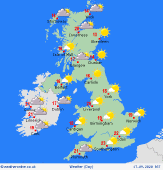 Thursday 17/09/20 Thursday 17/09/20
High pressure is squeezed slowly to the northeast on Thursday as a front approaches from the west. A largely dry and fine day across much of the UK and Ireland though eastern coastal regions of England and Scotland could see some mist and fog patches developing. Cloudier to the far northwest of Scotland with patchy light rain and drizzle arriving here later. Cooler in the south with highs at 23C here and 16C in the north.
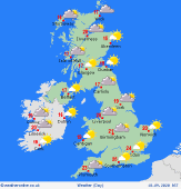 Friday 18/09/20 Friday 18/09/20
High pressure holds on to the east as a weak front makes its way across northern Scotland, brushing Northern Ireland too on Friday. This brings cloudier skies here and patchy, mostly light, rain. Staying dry and fine for England, Wales and Ireland although becoming breezy in the southwest of England as low pressure approaches from the south. Highs ranging from 15 to 25C.
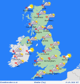 Saturday 19/09/20 Saturday 19/09/20
Saturday could see high pressure build back over northern parts of the British Isles while lower pressure stays to the south. A largely dry and fine day for most areas though southern parts of England will be cloudier with rain brushing the southern coast. It will be breezy here too. Highs range from 13 to 21C.
Sunday 20/09/20
High pressure stays to the north of the UK and Ireland on Sunday, but with low pressure close by southern areas expect outbreaks of rain for parts of southern England and possibly south Wales. Some of this could be heavy and potentially thundery at times. Turning more showery here later. Highs range from 12C in the far northwest to 20C in the southeast.
Monday 21/09/20
A slack pressure gradient across the British Isles on Monday allows for the development of mist and fog patches first thing. These perhaps slow to burn off but when they do it will be mostly dry and fine. Highs ranging from 15C in the north and 23C in the south.
Tuesday 22/09/20
Low pressure arrives from the northwest bring cloudy skies and outbreaks of rain to northwestern parts of Scotland and Ireland. High pressure to the southeast brings a dry and fine day to much of Ireland, England and Wales though there may be some early mist and fog patches again. Highs range from 15 to 25C.
|
