|
Issued: 0900 Saturday 11th January 2020
Duty forecaster: Claire Darbinyan
Unsettled, wet and windy, milder at times, but cooler days in Scotland
An unsettled week with low pressure dominating. There will be unsettled conditions and periods of rain as low pressure passes through. Temperatures will be varying with occasional spells of colder weather in Scotland, but generally milder to the south. It will be very windy at times too.
 For the weather for the next few days click here For the weather for the next few days click here
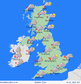
Tuesday 14/01/20
Low pressure to the north of Scotland brings a brighter, breezy day with frequent showers to the west, some of them heavy, some of them wintry. A separate area of low pressure develops to the southwest bringing heavy rain and high winds to Ireland, Wales and much of England. This reaches southern Scotland later where it falls as snow over the Southern Uplands. A drier day for Northern Ireland and eastern Scotland. Highs at 3 to 5C for Ireland, Scotland, Northern Ireland and northern England, 8 to 12C for Wales and central and southern England.
 Wednesday 15/01/20 Wednesday 15/01/20
A brighter day on Wednesday with a strong westerly flow over the UK and Ireland. This brings frequent showers to western areas, some of which will fall as snow over higher ground, with eastern areas being drier and brighter. A band of heavy rain may develop to the north of Scotland and sink slowly southward across the country through the day. This could bring heavy falls of snow to the Scottish Highlands. Staying breezy. Chilly with high temperatures at 4 to 9C.
 Thursday 16/01/20 Thursday 16/01/20
Thursday starts dry and bright though low pressure arrives later from the west and southwest bringing rain to much of the UK and Ireland. Perhaps staying dry, but cloudy, for northeastern Scotland. Windy again with gales possible to the south and east. High temperatures at 5 to 11C.
Friday 17/01/20
An area of low pressure clears to the east overnight bringing a westerly flow to the British Isles. Early rain clears southeastern England allowing drier, brighter conditions to follow across the country from the northwest. Showers persist for western areas, these wintry to the north and over higher ground. Highs ranging from 4 to 9C.
Saturday 18/01/20
A band of showery rain crosses Ireland and western parts of the UK through the morning, these fading over England and Wales. An area of low pressure arrives over Ireland later bringing heavier, more persistent rain here and to western parts of the UK. This turns to snow over the mountains of Scotland. Chilly with highs of 3 to 8C.
Sunday 19/01/20
Rain clears to the southeast on Sunday and higher pressure builds in from the southwest behind this bringing a mostly fine and dry day to the UK and Ireland. A weak front may bring light outbreaks of rain to northwest Scotland later. Highs at 2C in northern Scotland, 11C in the south of England.
|
