|
Issued: 1000 Wednesday 8th August 2018
Duty forecaster: David Hulse
Rain at times or showers through into mid-month
Showers at first. Rain moving east during the weekend but not reaching the east and southeast of England until later. The changeable theme continues into next week.
 For the weather for the next few days click here For the weather for the next few days click here
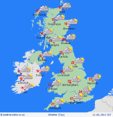
Saturday 11/08/18
A ridge of high pressure extending north across much of the British Isles will decline as low pressure tracks northeast to the northwest of Ireland. Confidence low to moderate in distribution and timing of rain. Rain, some heavy, moving northeast across Ireland, much of Scotland, although the far north may stay dry, and later Northwest England. Dry for much of England and Wales, though, with some sunshine and just an isolated shower. Highs 13 to 17C in the north and west, 19 to 22C in the south and east.
 Sunday 12/08/18 Sunday 12/08/18
Low pressure to the northwest of Ireland will drift east or southeast. Confidence remains low to moderate regarding movement of pressure systems and distribution of rain. Rain in northern and west areas will continue to edge south and east but turn more showery with bright or sunny intervals developing. East and southeast England are likely to stay dry until late in the day. Highs mainly 17 to 20C but perhaps locally exceeding 25C in Eastern England.
 Monday 13/08/18 Monday 13/08/18
Low pressure over northern parts of the British Isles will move away into the North Sea. A day of sunny intervals and showers, some heavy, for England, Ireland, Scotland and Wales. The showers will become few and far between later, though. Highs 13 to 17C in the north and west, 22 to 24C in the east and southeast of England.
Tuesday 14/08/18
Low pressure in the Northern North Sea continues to move away northeastwards but with weather fronts moving into western areas later. Sunny intervals and only isolated showers but with rain moving across Ireland during the second half of the day and into Western parts of Scotland, Wales and England later. Highs 13 to 17C in the north and west, near to 21C in the southeast.
Wednesday 15/08/18
Low pressure and associated weather fronts affecting northern and western parts of the British Isles. A band of heavy rain across Ireland, Scotland, Wales and Northern England edging south, followed by showers into northwestern areas. Southern England most dry but with some drizzle, chiefly in the southwest. Highs 13 to 18C in the north and west, locally 21C in the east.
Thursday 16/08/18
Low pressure close to Northern Scotland. A slow-moving band of rain affecting some northern and western parts but confidence low regarding position, perhaps Southern Scotland, Northern England and Wales, with sunny intervals and showers to either side of this zone. Highs 14 to 17C in the north and west, locally 21C in the east.
|
