|
Issued: 0930hrs Thursday 30th May 2019
Duty forecaster: Claire Darbinyan
Very warm in the south this weekend
A plume of humid air will move across the British Isles heading into the weekend, and temperatures will climb into the mid-20s for central and southeastern regions. Cooler to the west and north where there will be some rain and drizzle around. Unsettled through the next week with lots of showers and outbreaks of rain around.
For the weather for the next few days click here
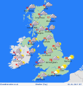 Sunday 02/06/19 Sunday 02/06/19
An area of low pressure arrives to the northwest of Ireland and sends fronts across the British Isles. A wet start to the day for Scotland and eastern parts of Ireland, dry but rather overcast for much of England and Wales. Rain will spread into England and Wales becoming increasingly showery though there will be some heavy bursts for Cumbria and the Lake District. Showers behind this to the west for Ireland and Scotland. Southeastern parts of England should stay dry. Highs up to 27C in parts of the southeast. More widely at 19 to 24C across England, 15 to 17C for the island of Ireland, Scotland and Wales.
 Monday 03/06/19 Monday 03/06/19
A fresher southwest to westerly flow is likely on Monday as a weakening cold front passes eastwards. A mix of sunshine and locally heavy showers. Rain may become more frequent in western Scotland as well as southwestern parts of England, Ireland and Wales. Breezy, or windy around coasts and hills in the west & north. The best of the brightness in the northeast. High temperatures at 14 to 20C, warmest east.
 Tuesday 04/06/19 Tuesday 04/06/19
A west to northwesterly flow for most areas on Tuesday bringing another mixed day of sunshine, showers and outbreaks of rain. The heaviest bursts of rain are expected to affect western parts of Scotland, southern Wales and southwestern and south-central parts of England. Showers possible for most other areas. Best of the brightness in the west. High temperatures at 13 to 19C.
Wednesday 05/06/19
Staying fairly changeable into midweek as low pressure remains to the northwest. Areas of showers, or locally frequent rain in the west & north. The southeast staying drier. Brightening from the west later. Highs at 13 to 18C.
Thursday 06/06/19
Detail and timing remain uncertain at this stage but an area of low pressure may arrive to the southwest of the British Isles bringing fresh winds and outbreaks of rain. Highs at 12 to 19C, coolest in southwestern areas.
Friday 07/06/19
Again, detail remains uncertain but low pressure may remain to the west bringing a mixture of sunny spells and showers. Some heavier rain possible for western Ireland. High temperatures at 14 to 19C.
|
