|
Issued: 0930 Sunday 29th November 2020
Duty forecaster: Claire Darbinyan
Cooler temperatures from mid-week
Stubborn fog patches are still to be expected through the start of this week as high pressure stays put. From midweek a front brings a cold airmass down across the country allowing for cooler temperatures and more mixed conditions with some wintry precipitation over higher ground.
For the weather for the next few days click here
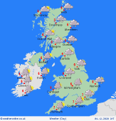
 Wednesday 02/12/20 Wednesday 02/12/20
A cold front moves across Scotland, Northern Ireland and Ireland through the early hours bringing outbreaks of rain here. As it moves across England and Wales later it manifests mainly as a band of thicker cloud though there may still be a few light, patchy outbreaks of rain associated with its passage. Behind this cooler air follows with with frequent showers over western coasts and hills. These turn wintry over higher ground. Highs at a chilly 5 to 8C for most, 9 or 10C to the far southwest.
 Thursday 03/12/20 Thursday 03/12/20
A trough of low pressure develops over the British Isles on Thursday. This brings mixed conditions with outbreaks of rain over western and southern areas. Rain readily turns to snow over higher ground in the north. A drier day for northern Scotland with the best of the sun to the northeast. A cold day, particularly in the north where highs will only reach 4C. Highs in the south reaching 8 or 9C.
 Friday 04/12/20 Friday 04/12/20
Low pressure will likely be centred over the UK on Friday bringing another very mixed day with outbreaks of rain and frequent showers. Again, these will readily turn to snow over higher ground. A few spells of sunshine will develop at times. Breezy for many and feeling cold too with highs of just 5 to 8C.
Saturday 05/12/20
Low pressure will likely drift south on Saturday allowing for drier and brighter conditions to develop over northern and western areas. Outbreaks of rain and showers focussed in the south and east. Staying breezy to the west and south. Highs of 4 to 8C.
Sunday 06/12/20
A slack pressure gradient over the British Isles on Sunday allows for a frosty start to the day with the potential for early mist and fog patches. Dry for many with some spells of sunshine though rain arrives over Ireland later. High temperatures of 4 to 8C.
Monday 07/12/20
Low pressure affects western areas on Monday though high pressure holds on in the east. Cloudy with patchy outbreaks of rain for Ireland and western parts of the UK. Staying drier for much of England and Scotland but with some cloud here. Highs of 4 to 8C.
|
