|
Issued: 0800 Tuesday 27th October 2020
Duty forecaster: Simon Keeling
Wind, rain and showers with a watch for severe storms, mild in the south
Becoming increasing unsettled through the course of this week. There will be periods of rain and showers together with strong winds. The potential for severe gales on some days and there is the potential for rogue storms bringing extreme gusts of winds. Temperatures tending to be mild in the south, cooler in Scotland, then cooler for all next week.
For the weather for the next few days click here
Friday 30/10/20
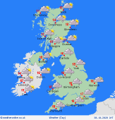
Another unsettled day on a Friday as a shallow area of low pressure crosses Ireland and the UK. This brings rain into Ireland and western parts of England and Wales through the morning, spreading eastwards through the afternoon although turning lighter and moe patchy. East Anglia and southeast England may stay dry although always some drizzle along southern coasts. Scotland will have some rain in the south but most other parts will be drier with sunny spells, apart from a few showers on western coasts. Highs at 16C in much of southern and eastern England, 14C in northwest England and Wales, 10 to 12C in Scotland and Ireland.
 Saturday 31/10/20 Saturday 31/10/20
A deep area of low pressure passing west of Ireland on Saturday will be bringing gale force winds to many areas, especially in the west. There will be clouds and periods of rain, most of it affecting Scotland, western England, Wales and Ireland. Eastern parts of England and Scotland are likely to see only patchy rain, although staying dry in the southeast until evening. Gales may become severe in Northern Ireland and western Scotland. A contrast in temperatures across the country with a mild 15 to 17C in much of England and Wales, but a cool 6 to 9C in Scotland.
 Sunday 1/11/20 Sunday 1/11/20
A wet day is likely for many on Sunday as fronts drive eastwards across the UK and Ireland. Rain could be heavy, mostly in the north and west. Brighter weather tending to arrive from the west through the day although with some heavy showers on western coasts and hills. More persistent rain could affect northern and western Scotland. Windy for many, gales in the northwest Scotland. Highs at 10 to 17C.
Monday 2/11/20
Staying unsettled on Monday as low pressure brings severe gales and heavy rain to all areas. This passes north and east although conditions should be turning brighter in the west later. Highs at a cool 7 to 10C, but nearer 16C in the far southeast.
Tuesday 3/11/20
A much cooler day for all on Tuesday with a mix of sunshine and showers. The showers will be heavy and thundery in the north and west with a risk of some hail too. Staying breezy. Highs at 9 to 12C.
Wednesday 4/11/20
A ridge of higher pressure building on Wednesday. This should bring a drier day with sunny spells, although a few showers affecting northern and western coasts and hills. Highs at 9 to 13C.
|
