|
Issued: 0900hrs Wednesday 7th September 2021
Duty forecaster: Alexi Venerus
Cooling off with some mixed weather this weekend, before higher pressure again next week
The current late summer hot spell eases off as low pressure moves in with fresher and cooler temperatures through this weekend. Next week sees the return of higher pressure once again with generaly settled weather but perhaps more cloud and showers for southeastern areas.
For the weather for the next few days click here
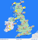
 Saturday 11/9/21 Saturday 11/9/21
High pressure begins to build from the west over the weekend. A north to northeasterly breeze affects many places on Saturday with fairly cloudy skies. Some patchy rain or showers, mainly central-southern Scotland and northeast England. Chance of a local shower elsewhere, but many places will be dry. Best of some sunshine in the morning across southern England, although some low-lying fog patches may occur. Top temperatures 17 to 22C, warmest in the southeast.
 Sunday 12/9/21 Sunday 12/9/21
High pressure extends back across the northern half of Britain resulting in a fair day with sunny spells for Scotland, Northern Ireland and much of northern England. East and southern regions are likely to be cloudier, with some showery rain possible near to English Channel coasts for a time. A fresh northeasterly breeze will take the edge off the temperatures in the south. A cool start with some fog patches in the north. Highs 16 to 19C.
 Monday 13/9/21 Monday 13/9/21
Quite a cool start to the morning for many places, especially in the north and west with clear skies and some low-lying fog. Breezier and cloudier in the far south. A mainly dry dry, but showery rain looking to affect southeastern parts of England with some lighter showers pushing along some southern coasts. An easterly breeze will be fresh in the south, light winds in the north. Highs 14 to 18C.
Tuesday 14/9/21
Low pressure over the near continent may just continue to play havok closer to our shores and bring some showery rain, perhaps heavy, across East Anglia towards the Midlands as well as across some southern counties. A drier and brigther day further north and west as higher pressure is the dominant feature across Scotland. Highs 14 to 19C.
Wednesday 15/9/21
If a similar pressure pattern continues and we see higher pressure sit towards the north northeast of Scotland we will continue with a cooler northeasterly flow keeping temperatures subdued and cloud and drizzle for many regions further south and east. Drier and brighter further northwest. Highs at 16 to 20C for most but cooler towards eastern coasts.
Thursday 16/9/21
Thursday may just see a more southwesterly flow move in towards northern and western areas as low pressure moves closer from the Atlantic. Cloudier skies perhaps here yet feeling relatively mild. Possible for some patchy rain later for western regions. Elsewhere, a slacker pressure gradient will bring rather cloudy skies but mostly dry conditions. Highs at 16 to 21C.
|
