|
Issued: 0900hrs Thursday 20th February 2020
Duty forecaster: Claire Darbinyan
Rain and hill snow at times
Atlantic weather patterns will continue to move across the British Isles over the coming week, with periods of rain or showers, with snow or hail mixed in at times over northern hills. Southern areas will be generally milder.
For the weather for the next few days click here
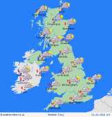 Sunday 23/02/20 Sunday 23/02/20
An area of rain is expected to pass west to east across Ireland, England and Wales. Heavy for several hours through the morning for western hills. Clearing to leave sunny spells and scattered showers as pressure builds from the west. Brisk winds around southern coasts. Cool in the north with hill snow for Scotland, highs at 4 to 7C. Mild in the south, highs at 11 to 13C.
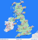
 Monday 24/02/20 Monday 24/02/20
A deep area of low pressure moves in from the west, with further rain focused on the north & west. Wintry in the north, with a spell of hill snow, perhaps to quite low levels in the Highlands. Windy with a risk of gales for west and northern regions. Much milder again in the southeast and largely dry, highs at 6 to 13C.
 Tuesday 25/02/20 Tuesday 25/02/20
A general westerly pattern prevails on Tuesday. Turning cooler for all as a cold front passes southeastwards with a spell of rain clearing. Areas of wintry showers follow into west & northern areas with a mix of rain, snow and hail. Highs at 3 to 9C.
Wednesday 26/02/20
Staying mixed with west to north-westerly winds. Areas of showers, most frequent north and west, with snow and hail over the hills. Central and southeastern England more often dry with some sunshine. High temperatures at 2 to 7C.
Thursday 27/02/20
A mixed pattern continues, with northwesterly winds bringing frequent showers, mostly in the west. These wintry over higher ground and to lower levels to the north. Southern and eastern areas stay largely dry. High temperatures at 1 to 8C.
Friday 28/02/20
Confidence is low but it could be that areas of low pressure bring outbreaks of heavy rain and strong winds to southern and western areas on Friday. This turns to snow over higher ground. Drier north and east. Highs ranging from 3 to 10C.
|
