|
Issued: 0930 Saturday 28th November 2020
Duty forecaster: Alexi Venerus
Fog still about over the coming days. A cold airmass moves in from midweek bringing frosty mornings and wintry precipitation.
Stubborn fog patches are still to be expected this weekend and into next week as high pressure and slack winds stay put. From midweek a cold front sweeps in a cold airmass down the country allowing for frosty starts and wintry precipitation at the end of the week and following weekend.
For the weather for the next few days click here
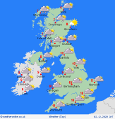
 Tuesday 01/12/20 Tuesday 01/12/20
High pressure remains dominant across much of the UK and Ireland on Tuesday. Misty and murky for many with some fog in places pparticuraly in the south. Winds strengthening across northern and western Scotland as well as western parts of Ireland with some rain moving into the far north of Scotland as well as west Scotland and western areas of Ireland and Northern Ireland. Other than some patchy light rain across southern England and Wales first thing it will be dry elsewhere. Cool in the north and east with highs ranging between 5 to 9C. Milder in the west with highs between 10-12C.
 Wednesday 02/12/20 Wednesday 02/12/20
High pressure still affecting much of England, Wales and Ireland with dry conditions and slack winds here. Breezier further north and west and a weak and patchy band of rain in the form of a cold front will push southwards across Scotland, Northern Ireland and into northern parts of England. Behind the front wintry showers are expected across northern and western Scotland as well as northwest Ireland. Highs at a chilly 5 or 6C in the north while a relatively milder 10 or 11C in the south.
 Thursday 03/12/20 Thursday 03/12/20
High pressure moves away on Thursday allowing a trough to move in. Remnants of the cold front in the form of patchy rian and cloud pass through southern and southeast England. Elsewhere, a mix of rain, sleet and snow will affect many western and central areas of the country, while eastermost places staying driest. A cold day, particularly in the north where highs will only reach 4C. Highs in the south reaching 8 or 9C.
Friday 04/12/20
Friday sees a widespread frost first thing across the north and west. Low pressure stays close by bringing rain across southeastern areas of England. Elsewhere it will be largely dry but with some wintry showers to some westernmost areas. Another cold feeling day. Highs of just 3 to 8C.
Saturday 05/12/20
A frosty start in the north and west again. Staying cold throughout the day in the north with some wintry showers about but again staying largely dry. Rain continuing to affect southeast England with showers up eastern coasts, these falling as a mix of rain, sleet and possibly snow across northeastern areas. Highs of 3 to 7C.
Sunday 06/12/20
Another widespread frost first thing once again across Scotland, northern England, parts of Wales and eastern regions of Ireland and Northern Ireland. Wintry showers expected across eastern coasts of Scotland and northeast England. More like rain showers for central and southern eastrn coasts of England. Largely dry further west. Highs of 3 to 8C.
|
