|
Issued: 1000hrs Saturday 24th March 2018
Duty forecaster: Garry Nicholson
Temperatures generally below average
Following a couple of bright days on Sunday & Monday, things turn unsettled by Tuesday, as fronts come in from the Atlantic. Areas of persistent rain or showers will influence the country heading toward Easter, and snow is likely over the hills, possibly to quite low levels at times. Generally cool, with frost and ice on some nights when skies clear.
 For the weather for the next few days click here For the weather for the next few days click here
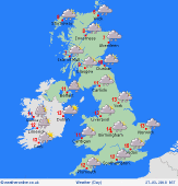
Tuesday 27/03/18
Low pressure across the country results in an unsettled day. Some places staying wet for many hours, focused on northern areas. Snow over the hills. Rain then showers for central and southern Britain. Blustery winds for some, local gales around exposed coasts. A little sun may break through. Fairly cool where rain lingers at 7 or 8C, but in brighter spells in the south, reaching 10 to 13C.
 Wednesday 28/03/18 Wednesday 28/03/18
Local detail very uncertain. Generally low pressure in charge. The remnants of previous fronts are likely to bring areas of rain or showers. Locally persistent falls. A risk of snow across the Scottish mountains. Some areas may escape drier with brighter periods. A lot of cloud, rare sunshine. Winds varied, locally blustery. Top temperatures ranging between 5 and 10C.
 Thursday 29/03/18 Thursday 29/03/18
Low pressure probably focused toward the south-west. Winds east or south-easterly. Feeling cool. Areas of showery rain, locally frequent. Snow over the hills in the north. Local variations mean some places will end up rather wet, whilst others may escape drier for many hours, but detail is very uncertain. Highs 5 to 10C.
Good Friday 30/03/18
Staying mixed or unsettled as low pressure remains nearby, probably centred south-west of Britain. Slow-moving fronts bring a risk of heavy rain to southern areas. Showers in the north, wintry over the hills, focused on the eastern Scottish Highlands and Pennines. Highs 5 to 9C.
Saturday 31/03/18
Generally east or southeasterly winds. Staying cool, perhaps quite cold, but confidence is low. Areas of showers, wintry over the hills. Driest in the west & north-west. Highs 5 to 9C.
Easter Sunday 01/04/18
Confidence stays low. Most likely chilly, with areas of wintry showers, most frequent in the north-east. Mostly rain at low levels. Occasional sun. Highs 5 to 9C.
|
