|
Issued: 0900 Tuesday 27th February 2018
Duty forecaster: Dr. Simon Keeling
Staying bitterly cold this week, snow towards the weekend, then probably less cold
Staying bitterly cold over the coming days. There will be snow showers, mostly in the east and some will be heavy. With an increased wind it will feel below -10C for many areas. By ate Thursday there is the risk of some more persistent snow arriving in the southwest, this then spreading north and east into Friday. Tending to turn less cold from the south during the weekend and into next week, but remaining mixed.
 For the weather for the next few days click here For the weather for the next few days click here
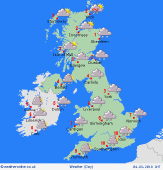
Friday 2/3/18
Low pressure to the southwest of Ireland on Friday. A front brings cloud, sleet and snow through Ireland, Wales, central and southern England during the day, this then edging slowly north into the Midlands and the rest of southern England in the afternoon. Cold for all with further heavy snow showers affecting the east of Scotland. Drier to the west. Highs at a cold 0 to -2C for most, 2C in the far southwest.
 Saturday 3/3/18 Saturday 3/3/18
Low pressure to the west and south of the country through Saturday. Bitterly cold air remains in Scotland and northern England as well as Ireland. A risk of snow across Ireland, northern England, Wales and the northern Midlands, as well as southern Scotland. Possibly milder in the far south of England although misty and murky here as more rain arrives in the afternoon. Snow showers in eastern Scotland but drier to the west. Highs at 1C in Scotland, 4C in the far south of England.
 Sunday 4/3/18 Sunday 4/3/18
Pressure stays low through Sunday. A front over Northern Ireland and southern Scotland as well as the far north of England brings the threat of some snow here. Cloud, rain and drizzle across much of central nd southern England, Wales and Ireland, although turning brighter in the far south later. Drier in western Scotland. Remaining bitterly cold in northern Scotland, a little milder to the south. Highs at 7C in southern England, 0C in northern Scotland.
Monday 5/3/18
Pressure is low to the south on Monday. Staying cold across much of northern England and Scotland with snow affecting central and northern Scotland. Further rain or showers in southern England, but probably drier elsewhere with some broken cloud. Highs at 1 to 3C in northern areas, 9C in the far south.
Tuesday 6/3/18
Low pressure over southern parts of the country brings sunshine and showers. The showers heavy and slow moving at times. A few showers affecting northeast England and eastern Scotland, these wintry at times. Tending to be drier in the west of Scotland. Highs at 3 to 8C.
Wednesday 7/3/18
Litle change on Wednesday with low pressure close by. This is going to be bringing a mix of sunny spells and showers. The showers in the east and south could be heavy at times. Northern and western areas tending to see fewer showers. Highs at 3 to 8C.
|
