|
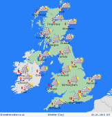
 Tuesday Tuesday
A brisk south to southwesterly wind. A front moves eastwards across the country, bringing a spell of rain to most places, heaviest in the west, tending to fade by afternoon. A second batch of heavy rain develops later, accompanied by a risk of gales into the evening. Snow over hills in Scotland and northern England. Highs 5 to 8C north & east, but milder air spreads from the south-west, reaching 10 to 12C.
 Tuesday night Tuesday night
Fronts drive in quickly from the west in the evening, and heavy rain will set in across western regions once again. Some further snow for northern hills. Wind strengthening to gale force, with gusts 60-70mph around western coasts of England & Wales, and reaching 50-60mph inland into the night. Possible damaging gusts causing disruption into Wednesday morning. Temperatures 1 to 6C, coldest Scotland.
 Wednesday Wednesday
Windy with frequent rain in the west, merging into constant rain for several hours in some hilly areas - snow over the mountains of Scotland. Possible hail and thunder. Brightest skies toward the east & north-east - glimpses of sunshine. Drier further east. Winds gusting 40-50mph even inland. Lighter winds across Scotland. High seas in the west & south may bring damage to coasts. Highs 5 to 9C.
 Thursday Thursday
Detail is uncertain. Light winds early in the day, but strengthening again from the south-west as another Atlantic low arrives. Clear and frosty at first in the north. A chilly day for northern Britain, but it may be dry and bright here. More rain moves in from the south-west as further fronts pile in. Some heavy and prolonged falls are possible. Snow over hills in the north. Highs 3 to 9C.
|
