|
 Thursday Thursday
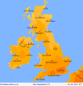
Pressure builds slowly on Thursday, with sunny spells for many. However, a trough of low pressure remains nearby, bringing scope for some showery outbreaks through the afternoon, these quite hit and miss, but may form into a band from central-southern Scotland, along the spine of the Pennines and locally into the Midlands & eastern England. Some of these may be thundery. Largely dry with sunshine for Wales, the southwest and the far northeast of Scotland. Highs 18 to 25C.
 Thursday night Thursday night
Outbreaks of rain and showers easing into Thursday evening leaving a dry night for most across the British Isles. There will be variable amounts of cloud around with clearer skies for Northern Ireland, Wales, southwest England and northeast Scotland. A risk of some localised mist or fog patches forming. Overnight lows widely ranging from about 11 to 16C.
 Friday Friday
Slack high pressure is expected to reside across the British Isles. Many places will be dry with sunny spells. A few showers popping up into the afternoon, these hit and miss, perhaps focused across western hills. Light winds and coastal breezes. Temperatures reaching 22 to 24C in central-western areas, locally a touch higher in favoured spots. Nearer 17C on eastern coasts with a breeze off the sea.
 Saturday Saturday
A slack pressure gradient across the British Isles on Saturday with higher pressure to the east of the UK, although low pressure over the Atlantic may begin to make inroads, with thickening cloud and patchy rain moving into Ireland and western coastal areas of Britain through the day. Chance of local showery bursts, some of them thundery, through the late morning and into the afternoon. Many eastern counties should stay dry with sunny spells. Southerly winds freshening around western coasts. Highs 15 to 25C, warmest southeast.
|
