|
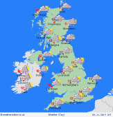 Monday Monday
Low pressure stays in charge into the new week with further zones of rain and heavy showers rotating across the country. Some persistent heavy falls in places. A mixed day on the whole though some spots to the north and west becoming generally dry as winds turn from the northeast later. A drier day for the Midlands too. High temperatures at 8 to 13C, coolest north and west.
 Monday night Monday night
Outbreaks of rain ease to the southeast through the night on Monday into Tuesday with drier conditions spreading across Scotland, Northern Ireland and Ireland. The clearest skies to the far west and far south of the country. Overnight lows widely at 5 to 8C.
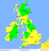
 Tuesday Tuesday
The wind continues to turn northeasterly across the country into midweek, with temperatures falling for most places. Clusters of showers spreading inland from North Sea and north-facing coasts. Frequent showers for southeastern areas as low pressure clears away. Brisk and chilly winds. Highs at 6 to 11C for most, 12 or 13C to the south.
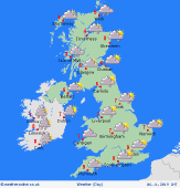 Wednesday Wednesday
Pressure may build a little from the west at first, with drier conditions for many, but a greater risk of frost in the morning. Light showers continue for North Sea coasts. Cloud builds from the west with outbreaks of rain for Ireland and, later, for western parts of the UK. Staying mostly dry but dull to the east. Highs 4 to 9C.
|
