|
 Friday Friday
A frosty and in some spots misty and foggy start across parts of England and Wales but this should clear for many to allow for sunshine to develop here through the day. Cloudier generally further north with drizzle and patchy rain at times across north and west Scotland. Best of any sunnier spells further east. Broken cloud across Ireland mostly dry, although some drizzle affecting western coasts. Cool across central and southern England with highs here around 4 or 5C, between 6 and 10C elsewhere.
 Friday Night Friday Night
Cloud cover and drizzle is expected rather extensively across Northern Ireland, Ireland and much of north and west Scotland in particular. Drier with some clear spells elsewhere, although there is the chance for mist and fog to develop across parts of England and Wales. Lows dropping below zero across parts of central and southern England and Wales seeing a frost here, perhaps a touch of frost for Northern Ireland and southern Scotland, above zero elsewhere.
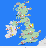
 Saturday Saturday
High pressure will be to the south of the country on Saturday. A frosty start for some again and there will be some mist and fog patches through many parts of England and Wales as well as eastern Scotland. Some lower cloud may affect western coast of England, Wales and Scotland with a risk of some drizzle here later in the afternoon. The best of any brightness is likely to be across more eastern areas. Highs at 5 to 8C for most.
 Sunday Sunday
A front sinks south down the country on Sunday bringing the wind flow into the north-west. This brings some outbreaks of rain through England and Wales, clearing from the north through the day where cooler air pulls south. Drier, brighter and feeling cooler further north, though showery rain affecting the west Highlands. Highs at 6 to 11C.
|
