|
Issued: 0530hrs Sunday 14th October 2018
Duty forecaster: Garry Nicholson
 Cooler than recent days Cooler than recent days
Good morning,
A complex frontal wave influences central and south-eastern England, as a trough of low pressure passes eastwards.
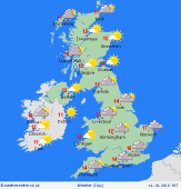
Wet in central and eastern England, with pulses of heavy rain setting in for several hours in places. The far south-east may escape dry for periods, but rain is likely to drift slowly eastwards through the day.
Pressure builds from the west, leaving much of Wales, western England, plus Scotland and Ireland with a dry and bright day. Just a few showers possible near coasts. Sunshine breaking through, although at times weak due to a shield of high cloud associated with fronts to the east.
Today's top temperatures will be much lower than Saturday, just 12 to 15C, feeling distinctly cool in rain and locally blustery winds.
Have a great day.
Garry
|
