|
Issued: 0530hrs Saturday 31st August 2019
Duty forecaster: Claire Darbinyan
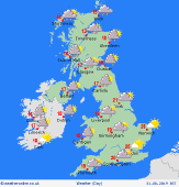 A freshening northwesterly flow brings cooler temperatures for most today. Wet & windy conditions for northwestern areas. Showery outbreaks of rain for much of England and Wales. These heavier to the west. A freshening northwesterly flow brings cooler temperatures for most today. Wet & windy conditions for northwestern areas. Showery outbreaks of rain for much of England and Wales. These heavier to the west.
Good morning,
It's another very wet and windy start to the day for those of you in western and northern Scotland and the Northern Isles with rain very slowly clearing northward through the morning. The heaviest rain has now passed for Ireland but some showers will linger through the morning. These may be heavier for eastern areas. A front brings showery outbreaks of rain across Wales and western England through the morning. This mostly showery in nature but there could be some heavy bursts at times.
This front sinks southeastward through the afternoon leaving bright conditions for much of England and Wales with just the slight chance of a shower. The area of heaviest rain and strongest winds continues to move to the north over Scotland but light rain may persist through the afternoon for northwest coasts and hills. Brighter and drier for central and southern Scotland. High temperatures at just 12 to 17C for Scotland, Northern Ireland, Ireland, northern England, Wales and the West Country; 19 to 24C for Yorkshire, the Midlands, eastern England and the southeast.
Rain continues to ease for most into Saturday evening though northwestern coasts and hills could see light rain or drizzle persist. Cloudy skies for much of England and Wales, clear skies over the island of Ireland and for eastern Scotland.
Have a great day!
Claire
|
