|
Issued: 0530hrs Tuesday 7th August 2018
Duty forecaster: Garry Nicholson
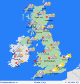
 Patchy rain north & west, some low cloud and murk Patchy rain north & west, some low cloud and murk
Good morning,
Slack pressure exists across Britain, with low pressure centred north-west of Scotland. A weakening cold front sinks south-eastwards, bringing variable cloud and a little rain in the north & west.
Hot and humid air for the south-east, where much of the day will be dry with hazy sunshine. Thunderstorms over northern France are expected to move across the eastern English Channel to affect south-east England and East Anglia by evening.
Torrential downpours may drop 25-50mm in an hour or so, resulting in local spot flooding, but very hit and miss. Isolated storms may affect the east/south-east of the Midlands.
Today's top temperatures will be a sultry 30 to 32C in the south-east, 26 to 29C for the Midlands, but nearer 17 to 20C for the north & west of Britain, also Ireland. Locally cooler in western Scotland.
Have a great day.
Garry
|


