|
Issued: 0900hrs Wednesday 29th January 2018
Duty forecaster: Garry Nicholson
Rain at times, brisk winds
February begins with west or southwesterly winds bringing mild conditions plus spells of wind and rain. Into next week, winds turn northwesterly for a time, and temperatures will drop again for a couple of days at least, with some wintry showers.
For the weather for the next few days click here
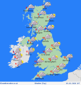
 Saturday 01/02/20 Saturday 01/02/20
Brisk and cool westerly winds affect the British Isles. Low pressure the north and a frontal system brings widespread rain and hill snow to Scotland, heaviest in the west. Showery in western England and Wales, with some organised showers possible for Northern Ireland too. Largely dry for central and eastern England with some sun. A front over southern counties brings cloud and rain or drizzle. Highs 6 to 9C.
 Sunday 02/02/20 Sunday 02/02/20
A spell of rain sweeps east across England and Wales in the early hours, perhaps continuing to affect East Anglia and the southeast into the morning, clearing to showers for the southwest. A front may trail back across northern England, parts of the Midlands and Wales, plus Ireland, where rain and low cloud may persist. Scotland sees sunshine and showers, wintry over the hills. Highs 6 to 12C.
 Monday 03/02/20 Monday 03/02/20
Detail is uncertain. Pressure stays generally low. Another front may extend across southern areas, bringing cloud and rain. Areas of showers for northern areas, again wintry over the mountains. A lot of cloud, some sunshine. Mild in the south, cooler north, highs between 5 and 12C.
Tuesday 04/02/20
Northwesterly winds and areas of showers, wintry over northern hills. Some organised areas of rain focused on north Wales and perhaps into the Midlands. Sunny spells away from showers. Cooler, highs 4 to 8C.
Wednesday 05/02/20
Northerly winds will maintain a cool feel through midweek. Showers affecting areas exposed to this wind, focused on northern Scotland, plus draped around some west and eastern coasts. Sunny and dry in central areas. Highs 3 to 7C.
Thursday 06/02/20
Pressure is likely to build from the west, with sunshine and just a few residual showers, most likely in the east. A frosty start, highs 5 to 8C, perhaps becoming milder in the northwest.
|
