|
Morning Call
- April 04, 2019
Chilly start
Heavy showers
|
|
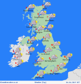
Issued: 0530hrs Thursday 4th April 2019
Heavy rain will spread from southwestern England into the West Midlands and the northwest through this afternoon. Heavy rain will also continue to affect the northeast of Scotland. Showers will continue over Ireland, though they will ease over mainland Scotland. High temperatures will widely reach 7 to 9C in towns and cities, though 10 or 11C is possible for eastern parts of England. Cooler in rural areas. Through the evening some heavy bursts of rain will continue to affect Ireland, Wales and western parts of England. A mostly dry evening for Scotland and the east of England though it will remain mostly overcast. The best chance of clear skies in the south of Scotland and north of England.
|

|
Weather Report [April 04, 2019]
|
|
Topics [April 04, 2019]
|