|
Issued: 0900 Wednesday 2nd August 2017
Duty forecaster: Simon Keeling
Staying mixed with rain or showers and feeling cool, although signs of a slight improvement later
The mixed weather is going to be continuing through the weekend and into next week. However, the god news is that there are signs of things settling down for some into the middle to later stages of the week as a ridge of high pressure builds from the west. It is going to be cool in the north and west of the UK and much of Ireland for most of the coming week, although warmer days are likely to the south and east. Becoming notably cooler for all early next week and windy at times too.
 For the weather for the next few days click here For the weather for the next few days click here
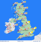
Saturday 5/8/17
Another showery day for Saturday with the westerly winds blowing in the showers. There are likely to be more showers around than on Saturday with most again across northern and western parts of the UK and Ireland. However, an odd heavier shower could occur just about anywhere, although there will be some sunny spells in-between. Highs at 15 to 18C in northern and western areas, but to 24C in southeast England.
 Sunday 6/8/17 Sunday 6/8/17
A ridge of high pressure brings a dry start to eastern parts of the country on Sunday. Lower pressure west of Ireland will be pushing cloud and rain eastwards during the day, most of this in Ireland, Wales and western England by evening, the east staying dry. Highs at 16 to 22C.
 Monday 7/8/17 Monday 7/8/17
Sunshine and showers on Monday as an area of low pressure passes through Ireland and the UK. The showers could be heavy at times with a risk of thunderstorms as well as longer periods of rain. The showers are likely to affect all parts of the UK and Ireland. Feeling cool. Highs near 15 to 19C.
Tuesday 8/8/17
Low pressure to the east with higher pressure to the west on Tuesday. This is going to be bringing a drier day across Ireland and western parts of the UK. More northern and eastern areas will have showers and these may be heavy along the coasts. Highs at 14 to 22C.
Wednesday 9/8/17
Still some showers left in northern and eastern areas on Wednesday as low pressure moves away. A ridge of higher pressure builds from the west bringing drier weather with sunny spells here. Highs near 16 to 23C.
Thursday 10/8/17
Higher pressure is likely to be in control of conditions on Thursday. This should bring a dry day with some good spells of sunshine. Feeling warmer too at 17 to 25C.
|
