|
Issued: 1000hrs Friday 3rd March 2017
Duty forecaster: Garry Nicholson
Cooler later in week
Low pressure will broadly influence the British Isles this weekend, bringing areas of rain or showers, but some brighter spells too. Next week, fronts moving in from the Atlantic will bring rain to the west and north-west, but it will become milder for a time. By the end of the week, it is likely to turn cooler as winds turn north-westerly.
For the weather for the next few days click here
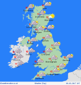
 Monday 06/03/17 Monday 06/03/17
A slack pressure regime influences the British Isles, whilst a small low is likely to pass from the south of Ireland into northern France. This may bring persistent rain to south-western Britain. Elsewhere, expect a scattering of showers, tending to move around slowly in light winds. However, there will also be plenty of dry weather, with sunny spells. Starting cool with local frost. Highs 7 to 11C.
 Tuesday 07/03/17 Tuesday 07/03/17
High pressure lies toward the south & east, whilst low pressure pushes fronts across Ireland. Starting cool with a slight frost. East & central Britain should stay dry most or all day. Sunshine gives way to thickening cloud, and rain is likely to develop across western regions during the daytime, becoming more widespread into the night. A freshening southerly breeze. Highs 8 to 12C.
 Wednesday 08/03/17 Wednesday 08/03/17
High pressure lies to the south by midweek, whilst fronts are likely to move across northern regions. Rain at times for Ireland and northern Britain, but southern and central areas should be largely dry. Best sunshine toward the east. A mild south-westerly flow. Breezy in the north. Highs 9 to 13C.
Thursday 09/03/17
Fronts are likely to extend from west to east across the country, although some uncertainty of detail. Rain likely at times across west & north-western areas. Mainly dry in the east and south, although a risk of some rain affecting Wales and extending into the Midlands. Highs 10 to 14C, mildest south.
Friday 10/03/17
Indications favour fronts slipping southwards, bringing some rain to most places through the day. Cool air follows from the north-west and showers are likely to become frequent across northern Britain & Ireland - turning wintry over high ground. Temperatures 9 to 12C south, 7C in the north.
Saturday 11/03/17
A cool north-westerly flow is likely to bring sunshine and showers - these locally heavy and frequent, with possible hail and thunder, plus snow over the hills. Brightest toward the south & east. Highs 5 to 10C.
|
