|
Issued: 0930hrs Friday 24th February 2017
Duty forecaster: Garry Nicholson
Temperatures lifting later in week
Storm Doris has passed, but the outlook remains unsettled as various weather systems move in from the Atlantic. Heavy rain and melting snow bring a risk of flooding to northern Britain this weekend. Next week will be cooler than recently, although temperatures near average. Rain frequent, heavy at times, with possible hail and thunder, plus hill snow. Some brighter spells. Local frosts.
For the weather for the next few days click here
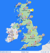 Monday 27/02/17 Monday 27/02/17
Low pressure centred to the north-west of Britain brings an unsettled day to most places. A cold front lies across the English Channel and the south-east, bringing a risk of persistent heavy rain for southern Britain. Elsewhere, clusters of heavy showers will spread from the south-west - possible hail and thunder, snow over the hills. The north-east should be driest and brightest. Squally south-westerly winds. Highs 7 to 10C.
 Tuesday 28/02/17 Tuesday 28/02/17
A broad area of low pressure becomes centred across the British Isles, resulting in another generally unsettled day. Areas of rain and heavy showers will move around slowly, giving frequent rain for many hours in some areas. Meanwhile, some places may escape dry for much of the day, but local detail uncertain. Risk of hail and thunder, plus hill snow. Blustery winds near coasts. Cool in rain, highs 6 to 10C.
 Wednesday 01/03/17 Wednesday 01/03/17
Confidence of detail is low by midweek. Conditions may improve across northern areas, with a risk of frost overnight where skies clear. Further fronts may move into the south-west, bringing a risk of persistent rain for some. Breezy in the south & south-west. Temperatures 7 to 11C.
Thursday 02/03/17
Low confidence of detail. Rain most likely toward the south-west, whilst the north-east is most likely to escape with drier weather. Possible local frost in north. Temperatures between 7 and 11C.
Friday 03/03/17
Low confidence. A mixed or rather unsettled outlook is likely, with areas of rain or showers. Some brighter spells with sunshine. Highs 8 to 12C.
Saturday 04/03/17
Confidence remains low: Pressure may try to build, bringing a brighter day for some, but a risk of rain remaining in the forecast. Highs 8 to 12C.
|
