|
Issued: 0900hrs Thursday 13th April 2017
Duty forecaster: Garry Nicholson
Occasional showers
A mixed Easter period, with rain or showers from time to time, mostly across northern areas, but also some lengthy dry periods for all. Next week is expected to see chilly but often dry conditions, with overnight frosts.
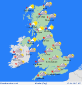
For the weather for the next few days click here
 Easter Sunday 16/04/17 Easter Sunday 16/04/17
High pressure lies to the south-west, whilst a frontal system moves into the north-west. A period of rain is expected to affect Scotland, Northern Ireland and increasingly northern England, although precise detail is uncertain. Central and southern areas are likely to stay dry, with the best of any sunshine around the south coast, particularly the south-west. A cool north-westerly breeze. Highs 9 or 10C north, 12 to 15C south.
 Monday 17/04/17 Monday 17/04/17
Outbreaks of rain pass south-eastwards overnight, leaving a legacy of cloud and showery rain across the country, although rainfall amounts mostly small. However, particularly by afternoon, a risk of heavier showers with hail in northern areas, and snow on the mountains. The south-west of Britain should fare best for dry weather and sunshine. A cool northerly breeze. Frost at dawn in the north. Highs 8 to 13C, warmest south-west.
 Tuesday 18/04/17 Tuesday 18/04/17
High pressure located to the west & north-west of Britain is likely to topple south-eastwards across the country, bringing a fair day with sunshine to many areas. Risk of residual showers in east, possible snow flurries. Fronts over the Atlantic may encroach into the far north-west of Scotland later. A cool north-easterly breeze, strongest in the south. Risk of widespread frost at dawn. Highs 7 to 11C.
Wednesday 19/04/17
High pressure is expected to reside broadly across Britain, maintaining settled weather for most. Weak fronts may drift into northern areas, producing cloud and and patchy rain, or snow on the hills. A good amount of sunshine. Widespread frost at dawn - temperatures likely sub-zero in rural areas. Highs 8 to 12C.
Thursday 20/04/17
High pressure likely centred toward the west, with a north-westerly flow affecting the country. Cloudy skies for the north-west, but a good deal of sunshine for many. Frost in the morning, particularly central-southern areas. Highs 9 to 14C.
Friday 21/04/17
Little change to the pattern. A cool north to north-westerly flow, but largely dry across Britain & Ireland. A few wintry showers in the far north of Scotland. Risk a frost at dawn. Highs 9 to 15C, warmest far south.
|
