|
Issued: 0900 Tuesday 9th May 2017
Duty forecaster: Simon Keeling
A mixed week ahead with most rain in the north and west
The expected weather change is going to be underway by Thursday as an area of showery rain tracks north. This leads into a more mixed weekend with a mix of sunshine and heavy showers. The mixed weather continues in northern and western areas early next week, although it is likel to be drier to the south and east.
 For the weather for the next few days click here For the weather for the next few days click here
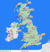
Friday 12/5/17
Low pressure centred over northern England on Friday. This may bring several hours of rainfall to Northern Ireland, northern England and the south of Scotland. To the south cloud and outbreaks of rain will fade with bright spells developing. Showers then form here in the afternoon, these heavy and thundery in places. he north of Scotland stays mostly dry although cloudy. Some rain in more eastern areas of Scotland. Highs at 10C in eastern Scotland, 17C in central and southern England.
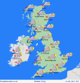 Saturday 13/5/17 Saturday 13/5/17
Low pressure is to the west of Ireland on Saturday. A southwesterly flow is going to allow showers to develop through the morning and into the afternoon. An od one could turn heavy, especially in the Midlands and eastern England. More persistent rain may affect the west of Ireland where it is going to be a cloudier day too. Highs near 14 to 17C.
 Sunday 14/5/17 Sunday 14/5/17
Troughs pass east on Sunday morning bringing showery bands of rain with them. These should clear to the east with sunny spells developing as a ridge of high pressure builds. There will be some sunny spells and mostly dry weather in the afternoon, although scattered showers across England, Wales and Ireland. The threat of heavier showers in Scotland, some thundery. Tops near 11 to 17C.
Monday 15/5/17
A ridge of high pressure is expected to build over England and Wales on Monday. This brings a mostly dry day with sunny spells, although always the threat of cloud affecting western and southern coasts and hills. Breezier and cloudier weather in Ireland and western Scotland where there is also the risk of rain. Highs at 14 to 19C.
Tuesday 16/5/17
A ridge of high pressure remains over England and Wales on Tuesday. Fronts passing east over Scotland and Ireland as wel as northern England. These bring cloud and some outbreaks of rain, most in the west. Highs near 15 to 19C.
Wednesday 17/5/17
The ridge of high pressure persists over southern and eastern part of the UK on Wednesday. This brings some good spells of sunshine and it should be dry too. The risk of some rain in western Scotland and Ireland as well as parts of northwest England. Highs at 20C in southeast England, 15C in western Scotland.
|
