|
 Thursday Thursday
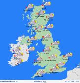
A windy and mild day for all parts of the country. Rain this morning is going to be mostly in western and southern areas, the heaviest of it across Wales and southwest England. A drier start to the day in the east, although cloud here. Rain this afternoon over northern England and most of Scotland, this light overall. Further rain in East Anglia and the southeast, again ost of it light. An area of severe gales may pass through southern Ireland this afternoon with more rain, these severe gales passing into Wales and southwest England later this afternoon and into this evening. Highs at 9 to 11C.
 Thursday Night Thursday Night
Staying windy through tonight with widespread gales, especially over western and southern coasts and hills. Showers in the west, some of them heavy. Turning drier in the east with cloud breaking as the night progresses. It is likely to be remaining windy. Lows near 5 to 7C.
 Friday Friday
Low pressure dominates the weather throughout the UK and Ireland on Friday. Bands of rain will be passing east, and there is a risk of a smaller area of low pressure bringing severe gales. It is uncertain at this time as to where the strongest winds and heaviest rain will be. There is a risk of some localised flooding. Highs at 7 to 10C.
 Saturday Saturday
Low pressure is again in control on the weather on Saturday, probably centred close to eastern coasts. This brings more periods of rain, some of them heavy. It may be windy in the east too. Drier weather to the west with some brighter spells, although a scattering of showers can't be ruled out on the coasts. A cooler day with highs at 5 to 8C.
|


