|
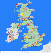 Friday Friday
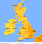
A slow moving frontal system brings heavy rain to Wales & south-west England for many hours. Patchy rain will slowly advance into central areas, perhaps a few showery bursts. Eastern England and much of Scotland will escape dry, although fairly cloudy. Rain pushes into south-west Scotland. Sunshine best in the far north. Rain on and off for Ireland. Highs 20 to 24C, warmest eastern England, but 13 to 15C in rain in west.
 Friday night Friday night
A band of heavy rain advances further east across central & southern England during the evening and night, and also pivots north across northern England. Rain clears from the south-west for a time, but will be followed by showers. By dawn, rain affects much of east & north-eastern England. Patchy rain for the south & south-east of Scotland, but much of the Highlands and far north will stay dry overnight. Blustery winds. Lows 9 to 14C.
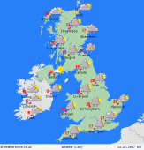 Saturday Saturday
Rain or showers for most places as low pressure dominates, but also some drier and brighter periods. A zone of persistent rain in the east & north in the morning will pivot slowly across Scotland giving rain for many hours. Heavy showers likely to break out increasingly for central & southern Britain - some slow-moving downpours afternoon & evening. Breezy for Scotland, also southern England, otherwise winds light. Highs 17 to 22C.
 Sunday Sunday
Low pressure lies to the east of Britain, whilst high pressure tries to build from the south-west. A mix of sunshine and scattered showers, although locally in east & northern areas the showers may become slow-moving and heavy into the afternoon. Best chance for staying dry is toward the south-west of England, and much of Wales. Winds variable, mainly west or north-westerly, gusty near showers. Highs 17 to 22C, up to 24C south-east.
|
