|
Issued: 0530hrs Saturday 25th February 2017
Duty forecaster: Garry Nicholson
 Flood risk in north-west Flood risk in north-west
Good morning,
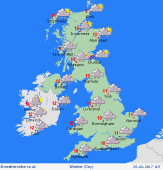
A mild south-westerly pattern affects the British Isles. Blustery winds, up to gale force in exposed areas in the west.
Slow-moving fronts bring persistent rain to the west & north-west, slipping slowly southwards through the day, turning wetter in the south-west toward evening.
Patchy rain moves across central & eastern areas, but southern counties of England should escape largely dry most of the day. Brighter conditions follow into the far north-west later.
Rain passes eastwards across central & southern Britain overnight, clearing by Sunday morning. Bright for many east & south-eastern areas on Sunday, but more heavy rain will arrive in the west & north-west.
Heaviest rain this weekend will affect western hills, totals 50 to 75mm, perhaps locally over 100mm. In the Lake District it may well rain all day during Saturday. Combined with snow melt on higher mountains, this brings a risk of flooding.
Temperatures will be 9 to 12C, mildest in the south & east, with little change on Sunday.
Have a great weekend.
Garry
|
